There are various mountains called Meall Buidhe scattered around Scotland, most of which are at the less-exciting end of the scale! This cannot be said for Meall Buidhe on Knoydart, which is a truly splendid mountain, with graceful lines, lovely ridges, steep sides, and some of the finest views imaginable. There are a clutch of Munros which have taken me two attempts to climb. Beinn na Lap (beaten back by bad weather), Ben Lui (problems parking and then deep snow), Ben Chonzie (white out), Cruach Ardrain (couldn't find summit cairn in blizzard), and Meall Buidhe (Knoydart). On a previous expedition, with a church walking group, we'd trekked in from Kinloch Hourn and camped at Barrisdale Bay. Our expedition over Ladhar Bheinn had been wonderful, but on our second day (in dreadful weather) we failed to find the ridge from Luinne Bheinn to Meall Buidhe. The compass readings seemed to be a bit odd, and there was some concern that iron in the rocks was giving us false readings, and so a decision was taken to abandon the walk and head back to the tents. It turned into a glorious evening too, with the sun sparkling on the waters of Loch Hourn. Nevertheless, the failure to gain the summit of Meall Buidhe meant that it was a challenge deferred.
That trip was over fifteen years ago, shortly after the birth of my first son, and years before my second son had even been contemplated! However, it was #2 son who accompanied me on my return to Knoydart last weekend. This time, we avoided the long walk in from Kinloch Hourn, and took the easier option of the boat from Mallaig to Inverie.
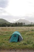
The campsite at Long Beach, Inverie provides plenty of space for tents, fire-places, logs for sale, a washing up area, a tap and a toilet. The situation of the site is perhaps a little unfortunate in that, even when there is a breeze by the pier in 'downtown Inverie' (!), Long Beach is so protected that the motionless air is a haven for midgies. To compensate for this, most campers had prepared open fires which were designed as smoke-bombs, to deter the ghastly little biters. At one point I cooked outside the tent, with a midgie-net over my head, and skin-so-soft on my hands, and passed the food into the tent so that my son could eat without himself being eaten! The water supply at the site has two interesting and
contrasting notices on it. The first is an official-looking Scottish Water one which warns campers of the dangers of drinking this untreated water, and advises that (as it is a potential carrier of bacterial infection), it should be boiled or chemically sterilised. The second is a local sign which re-assures campers that this is the same water that supplies all the local houses, that they are fine with it, and that we are welcome to sample the local water at our own risk! We risked it, and have not yet experienced any troublesome side-effects...
contrasting notices on it. The first is an official-looking Scottish Water one which warns campers of the dangers of drinking this untreated water, and advises that (as it is a potential carrier of bacterial infection), it should be boiled or chemically sterilised. The second is a local sign which re-assures campers that this is the same water that supplies all the local houses, that they are fine with it, and that we are welcome to sample the local water at our own risk! We risked it, and have not yet experienced any troublesome side-effects...
Using the 'composting toilet' is an interesting experience! I think that users should be
offered the same advise as those taken climbing in Skye. "You are going to be fine - just don't look down!"
offered the same advise as those taken climbing in Skye. "You are going to be fine - just don't look down!"
On Saturday morning, we bade farewell to out little tent, the midgies and the seashore and began our ascent of Meall Buidhe. There seems to be one main track leading from the village towards the mountains, behind Inverie House, and past the dramatically positioned monument on the little Torr a Bhalbhain above the Inverie River. Looking upstream, the valley splits into two, lying in a "Y-shape", with Meall Buidhe sitting right at the centre. To the left of the mountain, the track reaches Mam Barrisdale, the high pass over to Barrisdale Bay. The right hand fork, up the Gleann Meadail eventually reaches Mam Meadail, the bealach on the pass towards Sourlies Bothy and the great mountains of Glen Dessary and the "Rough Bounds of Knoydart". My son pointed out that not only does the scenery of Knoydart look like Middle-Earth, but that the place names here are also Tokeinesque. He added that Tolkein would have written Knoydar, without the "T" though.
Our first mistake of the day was to miss the right turn on the track which lead to the bridge over the Inverie River. We were too engaged in conversation, and by the time we realised it, had gone way too far along the main track towards the Loch-an-Dubh-Lochain. Cutting across the grass towards the bridge was a big mistake though. We ended up in really rough, and horribly boggy ground, which for my son meant a whole day of walking ahead of him with a soaking right foot.
Once we found the bridge, we were happily back on dry land for a few hours. The track past the Druim Bothy into Gleann Meadail is a decent one, and it leads all the way up the glen, with views back towards Inverie which become ever more impressive as height is gained. The Alt Gleann Meadail has a series of spectacular waterfalls to enjoy in the upper half of the glen too. After the soaking wet 'summer' we have endured this year, these were in full spate on Saturday and looked marvellous.
At Mam Meadail, the path turns SEwards and descends sharply down towards Sourlies. From here there is no obvious path leading up the
mountain, but several possible lines of ascent, all of which look marked with the boot-prints of hundreds of previous walkers. We pointed the compass at a line just East of due North and struck up the steepest section of the days walking. Wet, slippery, in a couple of places a bit scrambly we pulled ourselves up the 250m or so onto the ridge. The greatest danger here is not from exposure, as there isn't much of that, but from scree falling onto walkers below. One one occasion one very large boulder I stood on, began to slide down the hill, stopping not far from my son scrambling up behind me. After sustained heavy rain, this hillside is quite unstable and should be handled with some caution. Once the ridged is gained, all such difficulties vanish, and are replaced by a remarkably pleasant, broad grassy ridge running over a top and up to the Munro.
mountain, but several possible lines of ascent, all of which look marked with the boot-prints of hundreds of previous walkers. We pointed the compass at a line just East of due North and struck up the steepest section of the days walking. Wet, slippery, in a couple of places a bit scrambly we pulled ourselves up the 250m or so onto the ridge. The greatest danger here is not from exposure, as there isn't much of that, but from scree falling onto walkers below. One one occasion one very large boulder I stood on, began to slide down the hill, stopping not far from my son scrambling up behind me. After sustained heavy rain, this hillside is quite unstable and should be handled with some caution. Once the ridged is gained, all such difficulties vanish, and are replaced by a remarkably pleasant, broad grassy ridge running over a top and up to the Munro.
It was as we approached the cairn, that we realised that my son had dropped his GoPro camera when he had stumbled somewhere on the climb. He was absolutely gutted. It was sealed within its watertight case,
and so should be fine for some time up there. If you are reading this before heading up there, please keep your eyes open. If you see it, drop me a note in the comments! Despite this loss, we were gob-smacked by the views, with great mountains such as Ladhar Beinn and Sgurr na Ciche appearing and disappearing into cloud along with vast panoramas of mountains in tangles of peaks, impossible to identify individually.
and so should be fine for some time up there. If you are reading this before heading up there, please keep your eyes open. If you see it, drop me a note in the comments! Despite this loss, we were gob-smacked by the views, with great mountains such as Ladhar Beinn and Sgurr na Ciche appearing and disappearing into cloud along with vast panoramas of mountains in tangles of peaks, impossible to identify individually.
The top of Meall Buidhe is a great ridge which the 1:25,000 gives various names to. "Meall Buidhe" at it's highest Eastern end, "An t-Uriolloch" in the centre, and "Drium Righeanaich" it's long western arm, descending towards the base of the glen. Just as we stopped for lunch we were arrested by the sight of a
Golden Eagle circling in the Glen below us. Massive, distinctive and stunningly beautiful, it soared on the mountain winds for a few moments before changing its mind and flying off towards Beinn Buidhe to the South.
Golden Eagle circling in the Glen below us. Massive, distinctive and stunningly beautiful, it soared on the mountain winds for a few moments before changing its mind and flying off towards Beinn Buidhe to the South.
After descending the Druim Righeanaich to the valley floor, we headed straight for the bridge we could see, about a mile ahead of us, on the far side of what looked like a grassy field. In fact, in places this was more like a swamp, an sodden marsh of saturated peat and floating vegetation which was extremely awkward to cross without getting extremely wet. Progress across this last obstacle of the day was horribly
slow, and with a table booked at The Old Forge, we had a deadline to meet. After chatting to the only other walkers we saw all day, as they overtook us on the marsh, we made the track, the campsite, dry clothes and walked to the pub, just making our booked time.
slow, and with a table booked at The Old Forge, we had a deadline to meet. After chatting to the only other walkers we saw all day, as they overtook us on the marsh, we made the track, the campsite, dry clothes and walked to the pub, just making our booked time.
On the map, Meall Buidhe doesn't look like too much of a challenge. It's only one major climb, and the complete circuit is only about 14 miles. In reality however, it is a serious walk. While up on the mountain's glorious ridges the walking is undiluted joy; getting up onto, and then off, the ridges requires extensive battling with pretty hard-going underfoot conditions. After very heavy rain, these present quite tricky obstacles. The views that Meall Buidhe provides however, are simply unmissable!
Meall Buidhe from the campsite


No comments:
Post a Comment