"The A9 corridor" is the route that brings the Central Belt and The Highlands together. At its narrowest point in the high pass of Drumochter, the dual-carriageway road, the railway line, the ever-enlarging power lines and telecommunications masts, all jostle for space in the glen. The North-South direction of the road might be the link between the different ends of the country; but it also divides it, into Eastern and Western halves. Psychologically, being "East" or "West" of the A9 feels like visiting very different places, even if there are wonderful things like Glen Coe, or Lochnagar scattered each side of the line. It's not all in the mind, though. Meteorologists also divide their assessments of how wet and cold and battered I will be in the Scottish hills, along this frontier too.

After the car or the train descends from Drumochter on its Northern trajectory, and the road to Fort William and The West peels off by Dalwhinnie's distinctive distillery malting towers; the view is dominated by two great bulks. To the East of the A9 lie
The Cairngorms, the great mountains of the East. They are the hills which are worthy of a National Park, have ski-centres, and legends like the Big Grey Man of Ben Macdui. Historically though, these hills didn't use the nickname of their most famous peak, "The Cairngorm" as a collective term. Rather, these hills were known as
The Monadh Ruadh, (pronounced Monnar-ruwee), a name I think I prefer. Westwards, over to the left of the Northbound traveller lies T
he Monadliath (pronounced Monnar-leeya). These are less glamorous hills, they lack the great stories, the engineered paths and the vast car-parks of The Cairngorms. They are the Cairngorms little brother.
The Monadh Ruadh and The Monadhliath - two giant, unequal siblings standing each side of the A9 corridor.
Having walked over most of the hills and Glens of the Cairngorms/Monadh Ruadh, for a change I turned off the main road and drove through the little village of Newtonmore. About two-thirds of the way down the main street, a small left turn leads past a church building and up a small dead-end road which leads to Glen Banchor. To access the Monadliath hills, I drove as far down here as is allowed, and parked in the layby provided at the end of the public road.
A recently-re-bulldozed track leads northwards a few yards from the parking spot, and runs parallel to the Allt a Chaorainn, before running down to the riverside itself where it abruptly terminates. My first sight of the day was an almost-dead sheep lying in the heather, and then a huge bird of prey - rumbling down the glen towards it, like a great Vulcan bomber. It had presumably spotted the stricken creature from afar and was coming to work out how many nights food its corpse would provide.

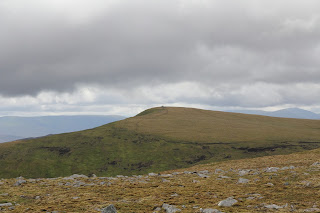
After the end of the bulldozed track, a small boggy footpath continues along the Eastbank of the river, before fording the river and then petering out in dense heather. Looking up the first ascent of the hill, a feint track is visible, passing a small. remote bothy high on the deserted mountainside. At the bothy the path strikes more northwards and climbs steadily up to the first summit of the day, A'Chailleach, a splendid viewpoint with a nice cairn and dry-stone windbreak. These hills may not be as glamorous as their larger siblings, which dominate the Eastward view, but they are wonderfully lonely hills. I had the whole place exclusively to myself.

Its hard to believe that A'Chailleach and Carn Sgulain are classed as two Munros. They certainly don't feel like separate mountains worthy of such an honour, especially when the scale of some of the mountains that have been demoted to 'tops' is considered. It wouldn't be a huge surprise if one of these were to be declassified at some point. Boot marks in the peat indicate that many people have trudged this way on the same (rather silly) bagging exercise that took me down into a very boggy gully, and then up a very steep grassy bank and on up to the little summit cairn of Carn Sgulain. Hazy sunshine, allowed murky views to be seen through the cloud, as the steadily building-
wind, howled across the plateau and tugged at my clothing.
If these first two hills seem to be on top of each other, the same is not the case for Carn Dearg. This most westerly of these hills lies several miles away from Sgulain, along a series of broad, indistinct, undulating tops, and ridges. Navigating along the various dog-legs of this route would be horrific in bad weather, were it not

for the fact that a line of extremely well preserved metal fence posts runs all the way from Carn Sgulain to Carn Ban, just next to the day's third Munro. It's worth following the zig-zags of these posts for the most part too. On one occasion where I didn't follow them, but cut the corner off, it led me into a pretty fierce bog. 2015 has been an exceptionally wet summer, the rivers are high and the bogs are like swamps in places up there. These fence posts are unusual for the Highland scenery - I wonder if anyone can tell me the story behind them? For a start they are hardly rusty at all, suggesting that they are of more recent origin than many of the ancient boundary markers that dot these hills. Then, it appears that all the wires haven't just rusted and fallen off, but been systematically removed, opening the hills for sheep or deer to roam freely across this watershed, estate boundary and county line.

I met several other walkers following these fence posts. Everyone else it seemed was walking this route anti-clockwise, except me! My reasoning was that Carn Dearg looked by far the best bit of the walk, and so I would save it to last. Their thinking was that it was better to walk these high plateaued miles down-wind, rather than with it blasting into their faces. In retrospect, they were almost certainly right, I certainly found it hard going at some points, the Radio Scotland hill forecast that morning had predicted gusts of up to 40mph, which was probably accurate.

The highlight of the walk from a scenery perspective was certainly the ascent of Carn Dearg, and walk up to its airy cairn. Carn Dearg is part of a North-South chain of tops, marked by a magnificent sheer-cliff face on their Eastern side, and slopes plunging down to Loch Dubh on the West. Strangely on this peak, my phone (on which there had been no reception all day) sprang into life. The highlight was a text from my Dad. Stuart Broad, Ben Stokes and Joe Root had just powered England to an Ashes clinching victory in Nottingham.
Descending from these hills is simple, but (like the ascent) rather boggy in places. A grassy terrace descends N/W from the low-point on the ridge between Carn Dearg and Carn Ban to the head of Gleann Ballach. Staying to the NE side of this glen to avoid the worst of the bogs, the gap between Meall na Ceardaich and Craig Liath soon leads down a bulldozed track running all the way back to the houses at Glenn Balloch.
Glen Balloch is a forlorn and sad looking place. While evidence of this being a working estate is obvious in the fencing work, extensive track work, and stalking information-signs for walkers; all the former dwelling houses deep in the glen have been abandoned. Closed, shuttered and weary looking, these buildings are just beginning to lose the battle with the elements, that will no doubt eventually raise them to the ground.
The walk back to the car from this sad place, is an easy one. There is broad track along the flat glen floor, and the car appears much sooner than expected. The walk out is much shorter than the westward route along the tops on the way out, courtesy of the cut-through route described above.
The Monadhliath are hills which I have seen many times, rising above the villages of Kingussie and Newtonmore, filling the skyline on many a Northwards or Westward drive through Scotland. It was great to finally be able to explore some of their main features and summits. They are not dramatic hills, and apart from Carn Dearg's lovely cliffs, devoid of many distinctive features. Nevertheless they form a magnificent high-level, wind-blown plateau, with great views, and a real feeling of space, a taste of remoteness where the walker can be pleasantly overwhelmed with a sense of his own smallness in the face of the vastness in which he is enveloped.


 After the car or the train descends from Drumochter on its Northern trajectory, and the road to Fort William and The West peels off by Dalwhinnie's distinctive distillery malting towers; the view is dominated by two great bulks. To the East of the A9 lie The Cairngorms, the great mountains of the East. They are the hills which are worthy of a National Park, have ski-centres, and legends like the Big Grey Man of Ben Macdui. Historically though, these hills didn't use the nickname of their most famous peak, "The Cairngorm" as a collective term. Rather, these hills were known as The Monadh Ruadh, (pronounced Monnar-ruwee), a name I think I prefer. Westwards, over to the left of the Northbound traveller lies The Monadliath (pronounced Monnar-leeya). These are less glamorous hills, they lack the great stories, the engineered paths and the vast car-parks of The Cairngorms. They are the Cairngorms little brother.
  After the end of the bulldozed track, a small boggy footpath continues along the Eastbank of the river, before fording the river and then petering out in dense heather. Looking up the first ascent of the hill, a feint track is visible, passing a small. remote bothy high on the deserted mountainside. At the bothy the path strikes more northwards and climbs steadily up to the first summit of the day, A'Chailleach, a splendid viewpoint with a nice cairn and dry-stone windbreak. These hills may not be as glamorous as their larger siblings, which dominate the Eastward view, but they are wonderfully lonely hills. I had the whole place exclusively to myself.
 Its hard to believe that A'Chailleach and Carn Sgulain are classed as two Munros. They certainly don't feel like separate mountains worthy of such an honour, especially when the scale of some of the mountains that have been demoted to 'tops' is considered. It wouldn't be a huge surprise if one of these were to be declassified at some point. Boot marks in the peat indicate that many people have trudged this way on the same (rather silly) bagging exercise that took me down into a very boggy gully, and then up a very steep grassy bank and on up to the little summit cairn of Carn Sgulain. Hazy sunshine, allowed murky views to be seen through the cloud, as the steadily building-


