Thursday, August 27, 2015
Sunday, August 23, 2015
Tuesday, August 18, 2015
Meall Buidhe (Knoydart)
There are various mountains called Meall Buidhe scattered around Scotland, most of which are at the less-exciting end of the scale! This cannot be said for Meall Buidhe on Knoydart, which is a truly splendid mountain, with graceful lines, lovely ridges, steep sides, and some of the finest views imaginable. There are a clutch of Munros which have taken me two attempts to climb. Beinn na Lap (beaten back by bad weather), Ben Lui (problems parking and then deep snow), Ben Chonzie (white out), Cruach Ardrain (couldn't find summit cairn in blizzard), and Meall Buidhe (Knoydart). On a previous expedition, with a church walking group, we'd trekked in from Kinloch Hourn and camped at Barrisdale Bay. Our expedition over Ladhar Bheinn had been wonderful, but on our second day (in dreadful weather) we failed to find the ridge from Luinne Bheinn to Meall Buidhe. The compass readings seemed to be a bit odd, and there was some concern that iron in the rocks was giving us false readings, and so a decision was taken to abandon the walk and head back to the tents. It turned into a glorious evening too, with the sun sparkling on the waters of Loch Hourn. Nevertheless, the failure to gain the summit of Meall Buidhe meant that it was a challenge deferred.
That trip was over fifteen years ago, shortly after the birth of my first son, and years before my second son had even been contemplated! However, it was #2 son who accompanied me on my return to Knoydart last weekend. This time, we avoided the long walk in from Kinloch Hourn, and took the easier option of the boat from Mallaig to Inverie.
The campsite at Long Beach, Inverie provides plenty of space for tents, fire-places, logs for sale, a washing up area, a tap and a toilet. The situation of the site is perhaps a little unfortunate in that, even when there is a breeze by the pier in 'downtown Inverie' (!), Long Beach is so protected that the motionless air is a haven for midgies. To compensate for this, most campers had prepared open fires which were designed as smoke-bombs, to deter the ghastly little biters. At one point I cooked outside the tent, with a midgie-net over my head, and skin-so-soft on my hands, and passed the food into the tent so that my son could eat without himself being eaten! The water supply at the site has two interesting and
contrasting notices on it. The first is an official-looking Scottish Water one which warns campers of the dangers of drinking this untreated water, and advises that (as it is a potential carrier of bacterial infection), it should be boiled or chemically sterilised. The second is a local sign which re-assures campers that this is the same water that supplies all the local houses, that they are fine with it, and that we are welcome to sample the local water at our own risk! We risked it, and have not yet experienced any troublesome side-effects...
contrasting notices on it. The first is an official-looking Scottish Water one which warns campers of the dangers of drinking this untreated water, and advises that (as it is a potential carrier of bacterial infection), it should be boiled or chemically sterilised. The second is a local sign which re-assures campers that this is the same water that supplies all the local houses, that they are fine with it, and that we are welcome to sample the local water at our own risk! We risked it, and have not yet experienced any troublesome side-effects...
Using the 'composting toilet' is an interesting experience! I think that users should be
offered the same advise as those taken climbing in Skye. "You are going to be fine - just don't look down!"
offered the same advise as those taken climbing in Skye. "You are going to be fine - just don't look down!"
On Saturday morning, we bade farewell to out little tent, the midgies and the seashore and began our ascent of Meall Buidhe. There seems to be one main track leading from the village towards the mountains, behind Inverie House, and past the dramatically positioned monument on the little Torr a Bhalbhain above the Inverie River. Looking upstream, the valley splits into two, lying in a "Y-shape", with Meall Buidhe sitting right at the centre. To the left of the mountain, the track reaches Mam Barrisdale, the high pass over to Barrisdale Bay. The right hand fork, up the Gleann Meadail eventually reaches Mam Meadail, the bealach on the pass towards Sourlies Bothy and the great mountains of Glen Dessary and the "Rough Bounds of Knoydart". My son pointed out that not only does the scenery of Knoydart look like Middle-Earth, but that the place names here are also Tokeinesque. He added that Tolkein would have written Knoydar, without the "T" though.
Our first mistake of the day was to miss the right turn on the track which lead to the bridge over the Inverie River. We were too engaged in conversation, and by the time we realised it, had gone way too far along the main track towards the Loch-an-Dubh-Lochain. Cutting across the grass towards the bridge was a big mistake though. We ended up in really rough, and horribly boggy ground, which for my son meant a whole day of walking ahead of him with a soaking right foot.
Once we found the bridge, we were happily back on dry land for a few hours. The track past the Druim Bothy into Gleann Meadail is a decent one, and it leads all the way up the glen, with views back towards Inverie which become ever more impressive as height is gained. The Alt Gleann Meadail has a series of spectacular waterfalls to enjoy in the upper half of the glen too. After the soaking wet 'summer' we have endured this year, these were in full spate on Saturday and looked marvellous.
At Mam Meadail, the path turns SEwards and descends sharply down towards Sourlies. From here there is no obvious path leading up the
mountain, but several possible lines of ascent, all of which look marked with the boot-prints of hundreds of previous walkers. We pointed the compass at a line just East of due North and struck up the steepest section of the days walking. Wet, slippery, in a couple of places a bit scrambly we pulled ourselves up the 250m or so onto the ridge. The greatest danger here is not from exposure, as there isn't much of that, but from scree falling onto walkers below. One one occasion one very large boulder I stood on, began to slide down the hill, stopping not far from my son scrambling up behind me. After sustained heavy rain, this hillside is quite unstable and should be handled with some caution. Once the ridged is gained, all such difficulties vanish, and are replaced by a remarkably pleasant, broad grassy ridge running over a top and up to the Munro.
mountain, but several possible lines of ascent, all of which look marked with the boot-prints of hundreds of previous walkers. We pointed the compass at a line just East of due North and struck up the steepest section of the days walking. Wet, slippery, in a couple of places a bit scrambly we pulled ourselves up the 250m or so onto the ridge. The greatest danger here is not from exposure, as there isn't much of that, but from scree falling onto walkers below. One one occasion one very large boulder I stood on, began to slide down the hill, stopping not far from my son scrambling up behind me. After sustained heavy rain, this hillside is quite unstable and should be handled with some caution. Once the ridged is gained, all such difficulties vanish, and are replaced by a remarkably pleasant, broad grassy ridge running over a top and up to the Munro.
It was as we approached the cairn, that we realised that my son had dropped his GoPro camera when he had stumbled somewhere on the climb. He was absolutely gutted. It was sealed within its watertight case,
and so should be fine for some time up there. If you are reading this before heading up there, please keep your eyes open. If you see it, drop me a note in the comments! Despite this loss, we were gob-smacked by the views, with great mountains such as Ladhar Beinn and Sgurr na Ciche appearing and disappearing into cloud along with vast panoramas of mountains in tangles of peaks, impossible to identify individually.
and so should be fine for some time up there. If you are reading this before heading up there, please keep your eyes open. If you see it, drop me a note in the comments! Despite this loss, we were gob-smacked by the views, with great mountains such as Ladhar Beinn and Sgurr na Ciche appearing and disappearing into cloud along with vast panoramas of mountains in tangles of peaks, impossible to identify individually.
The top of Meall Buidhe is a great ridge which the 1:25,000 gives various names to. "Meall Buidhe" at it's highest Eastern end, "An t-Uriolloch" in the centre, and "Drium Righeanaich" it's long western arm, descending towards the base of the glen. Just as we stopped for lunch we were arrested by the sight of a
Golden Eagle circling in the Glen below us. Massive, distinctive and stunningly beautiful, it soared on the mountain winds for a few moments before changing its mind and flying off towards Beinn Buidhe to the South.
Golden Eagle circling in the Glen below us. Massive, distinctive and stunningly beautiful, it soared on the mountain winds for a few moments before changing its mind and flying off towards Beinn Buidhe to the South.
After descending the Druim Righeanaich to the valley floor, we headed straight for the bridge we could see, about a mile ahead of us, on the far side of what looked like a grassy field. In fact, in places this was more like a swamp, an sodden marsh of saturated peat and floating vegetation which was extremely awkward to cross without getting extremely wet. Progress across this last obstacle of the day was horribly
slow, and with a table booked at The Old Forge, we had a deadline to meet. After chatting to the only other walkers we saw all day, as they overtook us on the marsh, we made the track, the campsite, dry clothes and walked to the pub, just making our booked time.
slow, and with a table booked at The Old Forge, we had a deadline to meet. After chatting to the only other walkers we saw all day, as they overtook us on the marsh, we made the track, the campsite, dry clothes and walked to the pub, just making our booked time.
On the map, Meall Buidhe doesn't look like too much of a challenge. It's only one major climb, and the complete circuit is only about 14 miles. In reality however, it is a serious walk. While up on the mountain's glorious ridges the walking is undiluted joy; getting up onto, and then off, the ridges requires extensive battling with pretty hard-going underfoot conditions. After very heavy rain, these present quite tricky obstacles. The views that Meall Buidhe provides however, are simply unmissable!
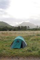
Meall Buidhe from the campsite
Monday, August 17, 2015
Knoydart Album
This is my photo album from a recent trip to Knoydart. The words in this post are the lyrics to the song "Knoydart", by John Lees, from the Barclay James Harvest album, "Caught in the Light". All photos enlarge - click on an image to see it properly!
On the road to nowhere, heading for Mallaig
I can feel the wild west highland breeze
Drive all my fears away
Through the raging Sound of Sleat
Safe on Spanish John
I can't wait for heaven's gate
It's paradise I'm looking on
Sky, nothing but blue sky all around
Sky, nothing but blue sky
Feel the silence calling all around
All around
Eagle high on Ladhar Bheinn
Heaven and hell beneath
Kinloch Hourn's where hell is born
And Nevis where the angels meet
Knoydart mends a broken heart
Heals a tortured soul
Brings new life to tired minds
And brightens eyes that look upon
Sky, nothing but blue sky all around
Sky, nothing but blue sky
Feel the silence calling all around
All around
Inverie, oh Inverie, ancient hearts of old
Ugly b______ one and all
We'll gather just to look upon
Sky, nothing but blue sky all around
Sky, nothing but blue sky
Feel the silence calling all around
All around
Monday, August 10, 2015
Sunday, August 09, 2015
Miles in the Monadhliath: A'Chailleach, Carn Sgulain and Carn Dearg
"The A9 corridor" is the route that brings the Central Belt and The Highlands together. At its narrowest point in the high pass of Drumochter, the dual-carriageway road, the railway line, the ever-enlarging power lines and telecommunications masts, all jostle for space in the glen. The North-South direction of the road might be the link between the different ends of the country; but it also divides it, into Eastern and Western halves. Psychologically, being "East" or "West" of the A9 feels like visiting very different places, even if there are wonderful things like Glen Coe, or Lochnagar scattered each side of the line. It's not all in the mind, though. Meteorologists also divide their assessments of how wet and cold and battered I will be in the Scottish hills, along this frontier too.
 After the car or the train descends from Drumochter on its Northern trajectory, and the road to Fort William and The West peels off by Dalwhinnie's distinctive distillery malting towers; the view is dominated by two great bulks. To the East of the A9 lie The Cairngorms, the great mountains of the East. They are the hills which are worthy of a National Park, have ski-centres, and legends like the Big Grey Man of Ben Macdui. Historically though, these hills didn't use the nickname of their most famous peak, "The Cairngorm" as a collective term. Rather, these hills were known as The Monadh Ruadh, (pronounced Monnar-ruwee), a name I think I prefer. Westwards, over to the left of the Northbound traveller lies The Monadliath (pronounced Monnar-leeya). These are less glamorous hills, they lack the great stories, the engineered paths and the vast car-parks of The Cairngorms. They are the Cairngorms little brother.
The Monadh Ruadh and The Monadhliath - two giant, unequal siblings standing each side of the A9 corridor.
Having walked over most of the hills and Glens of the Cairngorms/Monadh Ruadh, for a change I turned off the main road and drove through the little village of Newtonmore. About two-thirds of the way down the main street, a small left turn leads past a church building and up a small dead-end road which leads to Glen Banchor. To access the Monadliath hills, I drove as far down here as is allowed, and parked in the layby provided at the end of the public road.
A recently-re-bulldozed track leads northwards a few yards from the parking spot, and runs parallel to the Allt a Chaorainn, before running down to the riverside itself where it abruptly terminates. My first sight of the day was an almost-dead sheep lying in the heather, and then a huge bird of prey - rumbling down the glen towards it, like a great Vulcan bomber. It had presumably spotted the stricken creature from afar and was coming to work out how many nights food its corpse would provide.
 After the end of the bulldozed track, a small boggy footpath continues along the Eastbank of the river, before fording the river and then petering out in dense heather. Looking up the first ascent of the hill, a feint track is visible, passing a small. remote bothy high on the deserted mountainside. At the bothy the path strikes more northwards and climbs steadily up to the first summit of the day, A'Chailleach, a splendid viewpoint with a nice cairn and dry-stone windbreak. These hills may not be as glamorous as their larger siblings, which dominate the Eastward view, but they are wonderfully lonely hills. I had the whole place exclusively to myself.
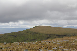
 Its hard to believe that A'Chailleach and Carn Sgulain are classed as two Munros. They certainly don't feel like separate mountains worthy of such an honour, especially when the scale of some of the mountains that have been demoted to 'tops' is considered. It wouldn't be a huge surprise if one of these were to be declassified at some point. Boot marks in the peat indicate that many people have trudged this way on the same (rather silly) bagging exercise that took me down into a very boggy gully, and then up a very steep grassy bank and on up to the little summit cairn of Carn Sgulain. Hazy sunshine, allowed murky views to be seen through the cloud, as the steadily building-
If these first two hills seem to be on top of each other, the same is not the case for Carn Dearg. This most westerly of these hills lies several miles away from Sgulain, along a series of broad, indistinct, undulating tops, and ridges. Navigating along the various dog-legs of this route would be horrific in bad weather, were it not
for the fact that a line of extremely well preserved metal fence posts runs all the way from Carn Sgulain to Carn Ban, just next to the day's third Munro. It's worth following the zig-zags of these posts for the most part too. On one occasion where I didn't follow them, but cut the corner off, it led me into a pretty fierce bog. 2015 has been an exceptionally wet summer, the rivers are high and the bogs are like swamps in places up there. These fence posts are unusual for the Highland scenery - I wonder if anyone can tell me the story behind them? For a start they are hardly rusty at all, suggesting that they are of more recent origin than many of the ancient boundary markers that dot these hills. Then, it appears that all the wires haven't just rusted and fallen off, but been systematically removed, opening the hills for sheep or deer to roam freely across this watershed, estate boundary and county line.
I met several other walkers following these fence posts. Everyone else it seemed was walking this route anti-clockwise, except me! My reasoning was that Carn Dearg looked by far the best bit of the walk, and so I would save it to last. Their thinking was that it was better to walk these high plateaued miles down-wind, rather than with it blasting into their faces. In retrospect, they were almost certainly right, I certainly found it hard going at some points, the Radio Scotland hill forecast that morning had predicted gusts of up to 40mph, which was probably accurate.
The highlight of the walk from a scenery perspective was certainly the ascent of Carn Dearg, and walk up to its airy cairn. Carn Dearg is part of a North-South chain of tops, marked by a magnificent sheer-cliff face on their Eastern side, and slopes plunging down to Loch Dubh on the West. Strangely on this peak, my phone (on which there had been no reception all day) sprang into life. The highlight was a text from my Dad. Stuart Broad, Ben Stokes and Joe Root had just powered England to an Ashes clinching victory in Nottingham.
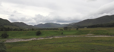
Descending from these hills is simple, but (like the ascent) rather boggy in places. A grassy terrace descends N/W from the low-point on the ridge between Carn Dearg and Carn Ban to the head of Gleann Ballach. Staying to the NE side of this glen to avoid the worst of the bogs, the gap between Meall na Ceardaich and Craig Liath soon leads down a bulldozed track running all the way back to the houses at Glenn Balloch.
Glen Balloch is a forlorn and sad looking place. While evidence of this being a working estate is obvious in the fencing work, extensive track work, and stalking information-signs for walkers; all the former dwelling houses deep in the glen have been abandoned. Closed, shuttered and weary looking, these buildings are just beginning to lose the battle with the elements, that will no doubt eventually raise them to the ground.
The walk back to the car from this sad place, is an easy one. There is broad track along the flat glen floor, and the car appears much sooner than expected. The walk out is much shorter than the westward route along the tops on the way out, courtesy of the cut-through route described above.
The Monadhliath are hills which I have seen many times, rising above the villages of Kingussie and Newtonmore, filling the skyline on many a Northwards or Westward drive through Scotland. It was great to finally be able to explore some of their main features and summits. They are not dramatic hills, and apart from Carn Dearg's lovely cliffs, devoid of many distinctive features. Nevertheless they form a magnificent high-level, wind-blown plateau, with great views, and a real feeling of space, a taste of remoteness where the walker can be pleasantly overwhelmed with a sense of his own smallness in the face of the vastness in which he is enveloped.
Subscribe to:
Comments (Atom)


